UNITED STATES NATIONAL PARKS
- chrissihuf
- May 21
- 12 min read
Updated: Jul 23

Below are all of the United States National Parks. I have not been to all of them (yet). The ones I have been to, are hyperlinked.
The National Park Service (NPS) was established in 1916 by President Woodrow Wilson. The National Park Service manages many different sites: National Parks, National Monuments, National Historic Sites, National Recreation Areas, National Seashores, and National Battlefields. The National Park Service manages more than 400 protected sites across the United States, including 63 official national parks.
National parks protect:
Bison
Wolves
Grizzly bears
Manatees
Ancient forests
Desert ecosystems
Coral reefs
Fun Facts
Wrangell–St. Elias National Park and Preserve is the largest U.S. national park.
Hot Springs National Park is one of the oldest federally protected areas.
Great Smoky Mountains National Park receives the highest annual visitation.
Gateway Arch National Park is the smallest official national park by area.
Good Resources
Yellowstone National Park (Wyoming, Montana, & Idaho): The First National Park, 1872. (UNESCO World Heritage Site)


This is such an amazing park! You can see just about any wild-life just roaming around. In 1872, Yellowstone National Park became the world’s first national park under President Ulysses S. Grant. Yellowstone’s geysers, hot springs, waterfalls, and wildlife made it internationally famous. The park has an expansive network of mud pots, vividly colored hot springs such as Grand Prismatic Spring, and regularly erupting geysers, the best-known being Old Faithful. If you’re visiting Grand Teton National Park, then Yellowstone should also be on your list, since they are so close together.
Yosemite National Park (California), 1890. (UNESCO World Heritage Site)
Pictures coming soon
Yosemite features sheer granite cliffs, exceptionally tall waterfalls, and old-growth forests at a unique intersection of geology and hydrology. Half Dome and El Capitan rise from the park's centerpiece, the glacier-carved Yosemite Valley, and from its vertical walls drop Yosemite Falls, one of North America's tallest waterfalls at 2,425 feet (739 m)high. Three giant sequoia groves, along with a pristine wilderness in the heart of the Sierra Nevada, are home to a wide variety of rare plant and animal species.
Chickamauga & Chattanooga National Military Park (Georgia & Tennessee), 1890.
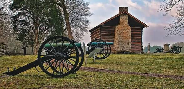
It is the nation's very first and largest national military park. If you want history and hiking, then this is the place for you! The park offers miles of hiking trails, driving tours, monuments, and historic visitor centers that discuss the 1863 Civil War campaigns.
Mount Rainier National Park (Washington), 1899.


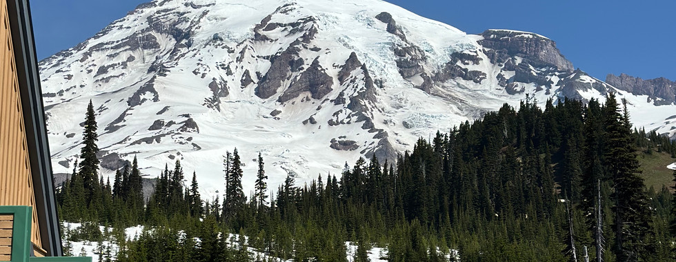


This is an active volcano, is the most prominent peak and is covered by 26 named glaciers including The Paradise area on the south slope is among the snowiest places on Earth. We came in May after Memorial Day and there was a lot of snow still, but we still did the Skyview Trail. This mountain is absolutely breathtaking. We also did a stop to Narada Falls… what an impressive waterfall this is! If you take the trail down to the falls, take your pictures and then continue on the beautiful trail for more amazing views.
Wind Cave National Park (South Dakota), 1903.

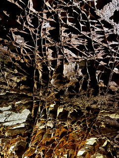


This is such an amazing cave and should be on your bucket-list! This cave alone, has 95% of all boxwork formations on Earth. Boxwork is a very rare geological feature, it is distinctive for its calcite fin formations. It is one of the longest caves in the world and creates a wind as air pressure changes.
Muir Woods National Monument (California), 1908.


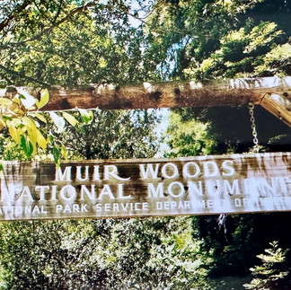

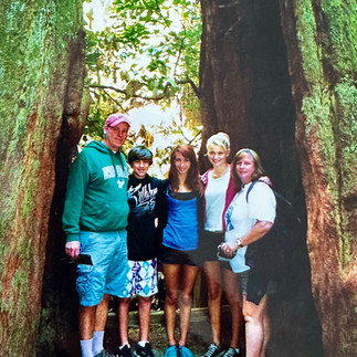
I am so glad that Muir Woods is a federally protected site. Words and pictures cannot signify the enormity and beauty of this place. When visiting this part of California, this is a must see!
Rocky Mountain National Park (Colorado), 1915. (UNESCO World Heritage Site)


There are so many things to do at this amazing National Park! We had two full days to hike and explore, which is not enough time. Take your time and immerse yourself in this beautiful land. Lots of hiking and animal viewing.
Grand Canyon National Park (Arizona), 1919. (UNESCO World Heritage Site)


The Grand Canyon was carved by the Colorado River. This is usually on everyone’s bucket-list and there’s a reason… it’s totally amazing and pictures (no matter how good) do not do this natural wonder justice.
Zion National Park (Utah), 1919.
Pictures coming soon
The various sandstone formations and the forks of the Virgin River create a wilderness divided into four ecosystems: desert, riparian, woodland, and coniferous forest. This is such a beautiful park.
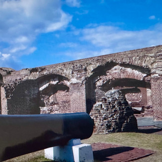
Fort Pulaski National Monument (Georgia), 1924.


What a great monument in Southeast Georgia! It was constructed in the 1830s and 1840s (initially overseen by a young Robert E. Lee) and played a pivotal role in the Civil War. There is the historic fort, a museum, hiking/biking trails, and views of the Cockspur Island Lighthouse.
Statue of Liberty National Monument (New York), 1924. (UNESCO World Heritage Site)
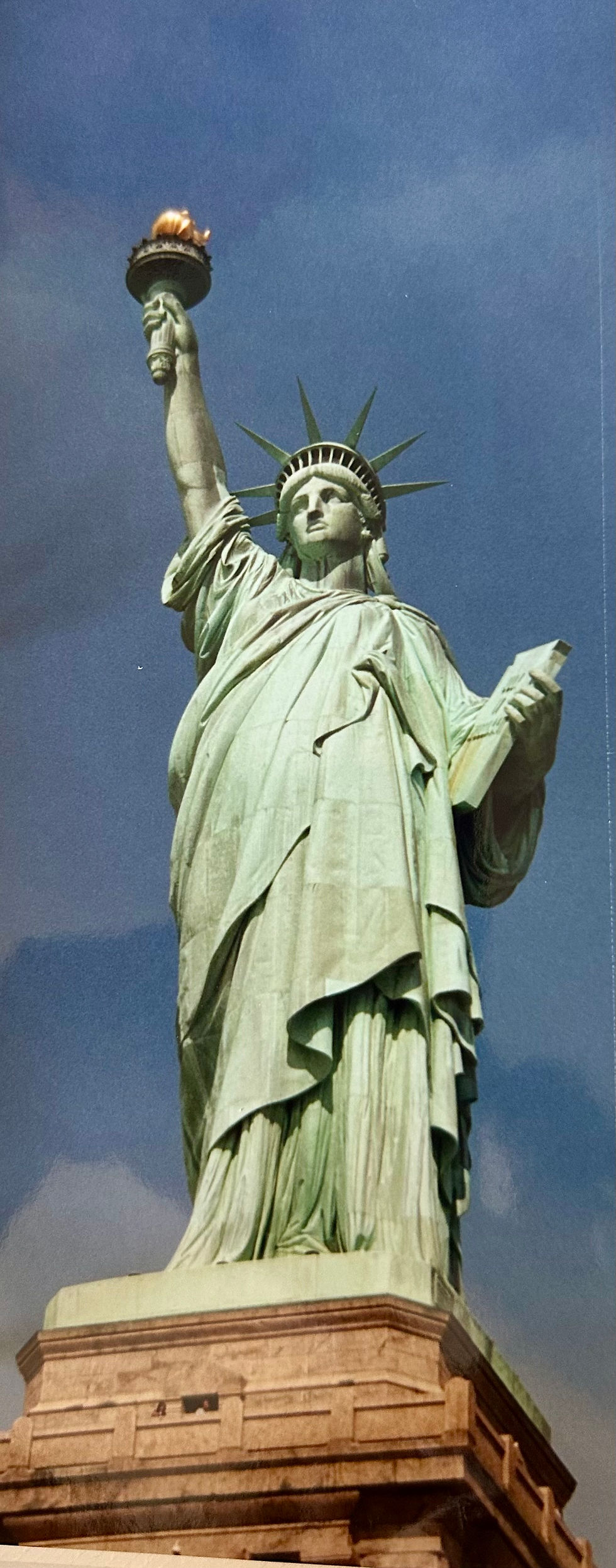
When visiting New York, one of the ‘must see’ items should be Ellis Island and the Statue of Liberty. She is such a historic monument and means so much to so many Americans. The original 1924 designation included only the statue and the small footprint of the former Fort Wood on Liberty Island. Over the years, the monument was expanded to encompass the rest of the island and nearby Ellis Island.
Castillo de San Marcos National Monument (Florida), 1924.

Saint Augustine itself is a wonderful place and filled with so much history, and this monument fits right in!
Bryce Canyon National Park (Utah), 1928
Pictures coming soon
Bryce Canyon is not technically a canyon—it’s a series of natural amphitheaters carved by erosion. There is some great hiking and scenic drives. This is a beautiful place to visit.
Grand Teton National Park (Wyoming), 1929.


If you’re visiting Yellowstone, then Grand Teton National Park should also be on your list, since they are so close together. The beauty of this place is breathtaking.
Cowpens National Battlefield (South Carolina), 1972.


Many people just pass right by and don’t even give it a thought. This is such a nice and tranquil park with a very nice trail with history markers along the way. It preserves the site of the pivotal January 1781 American Revolutionary War victory.
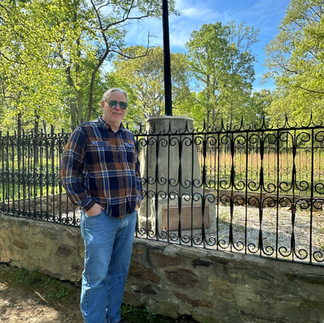
Kennesaw Mountain National Battlefield Park (Georgia), 1933


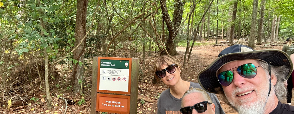


This mountain was practically in our back yard, so we hiked to the top and around and down many times in the 28 years of living in Georgia. It’s actually a lot bigger than you think (2,965 acres). It was in a major part of the Civil War of 1864.
Mount Rushmore National Memorial (South Dakota), 1933

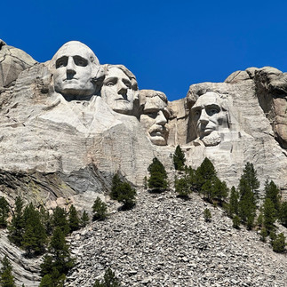


This is actually designated as a National Memorial, not a National Park, but made the list anyway. This is a pretty cool and unique place. The carving of the mountain was from 1927-1941 (a long time).
The Four Presidents
George Washington: Represents the nation's founding and the Revolutionary War.
Thomas Jefferson: Represents the nation's expansion through the Louisiana Purchase.
Theodore Roosevelt: Represents the development of the country and the conservation of its natural resources.
Abraham Lincoln: Represents the preservation of the United States during the Civil War.
Lincoln Memorial (Washington, D.C.), 1933
Pictures coming soon
When in Washington D.C., visiting the monuments is a must, and visiting the Lincoln Memorial should be on your list. It is an amazing sculpture for our 16th president.
Fun Facts:
Architectural Symbolism: The memorial has 36 Doric columns, representing the 36 states in the Union at the time of Lincoln's death. Above the columns, the names of 48 states are carved, reflecting the Union's size when the monument was completed.
The Giant Statue: Sculpted by Daniel Chester French, the 175-ton seated Lincoln is carved from 28 pieces of white Georgia marble.
The Famous Typo: An engraving error on the north interior wall accidentally spelled out the letter "E" instead of "F" in the word "future" during the painting of his Second Inaugural Address. While patched over, the faint outline is still visible to eagle-eyed visitors.
The Undercroft: Built over swampy tidal flats, the monument is anchored by deep concrete pillars. This hidden three-story basement features stalactites and structural cartoons drawn by early construction workers.
Civil Rights History: On August 28, 1963, Dr. Martin Luther King Jr. delivered his legendary "I Have a Dream" speech from the steps. The exact spot he stood is etched into the marble landing for visitors to see.
On Currency: If you look closely at the back of a U.S. penny and a five-dollar bill, you can see the Lincoln Memorial situated behind his portrait
Great Smoky Mountains National Park (North Carolina and Tennessee), 1934. (UNESCO World Heritage Site)
Pictures coming soon
The Great Smoky Mountains, are part of the Appalachian Mountains. Hiking is the park's main attraction, with over 800 miles of trails. The beauty and wildlife are amazing.
Everglades National Park (Florida), 1934. (UNESCO World Heritage Site)
Pictures coming soon
The Everglades are the largest tropical wilderness in the United States. It is a mangrove and tropical rainforest ecosystem with marine estuary that is home to 36 protected species. This is where you can see what Florida really looked like.
Jamestown Historical Park (Virginia), 1934.
Pictures coming soon
This historical park is amazing. It is the actual location of the first permanent English settlement in North America, established in 1607, and is still being excavated. It is a living-history museum
Yorktown Historical Park (Virginia), 1930.
Pictures coming soon
Here’s another amazing park that’s filled with American Revolutionary history! This place is the exact sites where American independence was secured during the Revolutionary War.
Blue Ridge Parkway (Virginia & North Carolina), 1936.
Pictures coming soon
This is a 469-mile scenic roadway connecting Shenandoah National Park (Virginia) to the Great Smoky Mountains National Park (North Carolina). It is the longest linear park in the U.S. It took 52 years to complete the highway, with the final section (near Rough Ridge in North Carolina) officially opening in 1987. You can drive the entire 469 miles from start to finish without ever encountering a stop sign or a traffic light. Large semi-trucks are prohibited, which preserves the relaxing, recreational nature of the drive. There are 26 tunnels along the route.
Olympic National Park (Washington), 1938. (UNESCO World Heritage Site)


This park on the Olympic Peninsula includes a wide range of ecosystems from Pacific shoreline to temperate rainforests to glaciated alpine peaks, the tallest of which is Mount Olympus. We came from Seattle which was about a 3 hour drive and went straight up to Hurricane Ridge (beautiful but high hike). What an incredible view there is, you can even see Canada from there. We then went to Marymere Falls (not as high but still beautiful). Our last hike was Spruce Railroad Trail, this is paved and flat, if you turn to go to Devil’s Pond, be ready for lots of elevation and a real trail. There are so many hikes to choose from on this massive mountain. We spent the night at the Log Cabin Resort.
Little Bighorn National Monument (Montana), 1890.


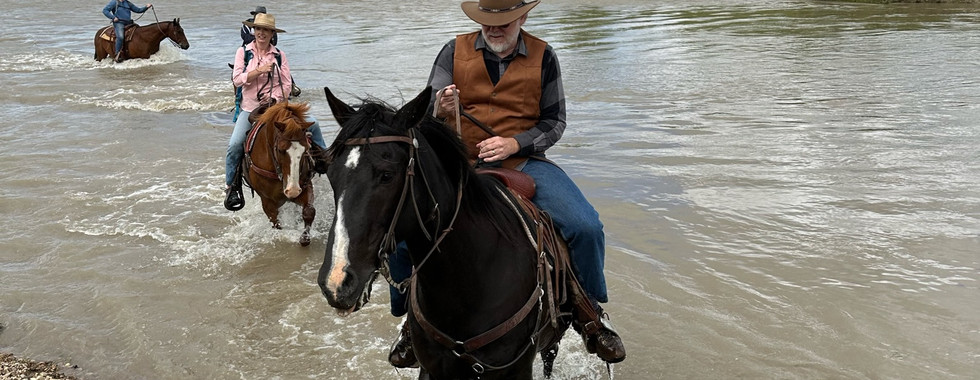


This park is located in Crow Agency, Montana, the site of the 1876 Battle of the Little Bighorn and includes the Custer National Cemetery. We took a horseback riding tour through this massive park, and were led by a Native American Crow member. Booked through Little Bighorn Tours.
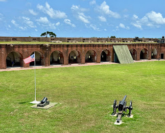
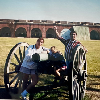
Fort Sumter National Park (South Carolina), 1948.


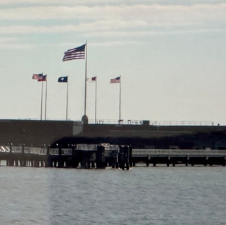
This is where the first shots were fired on April 12, 1861 for the American Civil War.
Interesting facts:
Built on a Sandbar: Because Fort Sumter was constructed on an artificial island, it required nearly 70,000 to 100,000 tons of rough granite and granite blocks to create a foundation before a single brick could be laid.
Slaves Made the Bricks: While the fort itself was not built by slaves, the estimated 4,000,000 bricks used in its construction were manufactured using slave labor at local South Carolina plantations.
No Fatalities in the Opening Battle: The 34-hour bombardment that initiated the Civil War resulted in zero combat fatalities for either side. The only casualty during the engagement was a Union soldier who was killed by an accidental explosion during a 100-gun salute evacuation ceremony.
Nearly 4 Years Under Siege: The Confederacy held Fort Sumter for the majority of the war. After the initial battle, Union forces heavily bombarded and attempted to recapture it, resulting in the Confederates successfully defending the stronghold for 587 days against Union troops and Navy vessels.
The Ironic Flag Ceremony: On April 14, 1865, Major Robert Anderson (who originally surrendered the fort) returned to raise the Union flag over Sumter in a ceremonial event. President Abraham Lincoln was invited to the ceremony, but he declined to attend because he had a fateful appointment that evening at Ford's Theatre.
Taos Pueblo Historic Park (New Mexico), 1960. (UNESCO World Heritage Site)

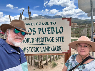


Taos Pueblo is an actively inhabited Native American community. It’s very interesting to visit a place so old, still inhabited, and continues to thrive.
Cape Cod National Seashore (Massachusetts), 1961.
Pictures coming soon
Cape Cod National Seashore is the first national seashore established in the United States. It stretches across six towns—Provincetown, Truro, Wellfleet, Eastham, Orleans, and Chatham—and includes beaches, biking trails, and historic lighthouses. No matter what time of year, it’s beautiful here.
Petrified Forest National Park (Arizona), 1962
Pictures coming soon
This is an eerie yet amazing park. This is part of the Painted Desert. It has a large concentration of 225-million-year-old petrified wood. Dinosaur fossils and over 350 Native American sites are also protected in this park.
Ellis Island National Park (New York), 1961.
Pictures coming soon
When visiting New York, one of the ‘must see’ items should be Ellis Island and the Statue of Liberty. She is such a historic monument and means so much to so many. The original 1924 designation included only the statue and the small footprint of the former Fort Wood on Liberty Island. Over the years, the monument was expanded to encompass the rest of the island and nearby Ellis Island. This was the nation's premier federal immigration station from 1892 to 1954, processing approximately 12 million immigrants.
Appalachian National Scenic Trail (Georgia through Maine), 1968.


Appalachian Trail (A.T.) is a continuous 2,197.9 mile footpath stretching from Georgia to Maine. You can take much time off from the world and hike all the way through, or you can hike it in segments when you have the time (this is what my husband is doing). The trail passes through 14 states along the crests and valleys of the Appalachian Mountains.
Andersonville National Historic Park (Georgia), 1970.


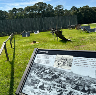


Officially known as Camp Sumter, this was the largest and most notorious Confederate military prison during the American Civil War. Built to hold 10,000 prisoners, the stockade eventually held over 45,000 total over its lifespan, peaking at around 33,000 inmates at a single time.
Capitol Reef National Park (Utah), 1971
Pictures coming soon
The park's Waterpocket Fold is a 100-mile (160 km)monocline that exhibits the earth's diverse geologic layers. Other natural features include monoliths, eroded buttes, and sandstone domes, including one shaped like the United States Capitol.
Located in south-central Utah, Capitol Reef National Park spans 241,904 acres of stunning desert landscape. Famous for the Waterpocket Fold—a massive 100-mile-long wrinkle in the Earth’s crust—the park gets its name from its soaring white sandstone domes that resemble capitol buildings, and its sheer, reef-like cliffs. [1, 2, 3]
The Geologic Marvel
The Waterpocket Fold: This 65-million-year-old formation is the largest exposed monocline in North America, creating a dramatic, rugged barrier of cliffs and canyons.
Elevation Extremes: Elevations range from a low of 3,877 feet at Hall's Creek to a high of 8,960 feet near Billings Pass.
The "Reef": The name is a blend of "Capitol" (the domes) and "Reef" (the rocky cliffs acting as an impassable barrier to early travelers). [1, 2]
History & Culture
Ancient Inhabitants: The Fremont culture lived in the area around the year 1000, leaving behind fascinating, ancient petroglyphs carved into the canyon walls just east of the visitor center.
The Fruita Orchards: Early Mormon settlers planted extensive fruit orchards in the desert oasis of Fruita. Today, the National Park Service maintains thousands of fruit trees, and visitors can pick and eat cherries, peaches, and apples during the harvest season.
Creation: Originally dubbed "Wayne Wonderland" by local promoters in the 1920s, it was declared a National Monument in 1937 and officially became a National Park on December 18, 1971. [1, 2, 3, 4, 5, 6]
Park Activities & Distinctions
International Dark Sky Park: Designated in 2015, the park's extreme isolation makes it one of the absolute best spots in the U.S. for pristine stargazing.
Entrance Free Zones: Because Utah Highway 24 cuts directly through the park, a large portion of the area can be explored for free. Fees are only required if you pass the Fruita Campground onto the Scenic Drive.
Visitor Stats: The park welcomes roughly 1.4 million visitors annually, providing a much more solitary and uncrowded experience than some of Utah's busier "Mighty 5" parks. [1, 2, 3, 4, 5, 6]
To plan your trip, check real-time conditions, and learn about camping reservations at the famous Fruita Campground, visit the official National Park Service website. [1, 2, 3, 4]
Canaveral National Seashore (Florida), 1975.


Canaveral National Seashore is situated on a barrier island between New Smyrna Beach and Titusville, FL. It is accessible via Apollo Beach or Playalinda Beach. There is an entrance fee, but National Park passes are accepted.
Badlands National Park (South Dakota), 1978


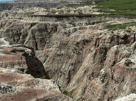


The Badlands are like no place I’ve ever seen… looks like you’re walking on top of the moon (but a lot hotter!). I feel like this is more of a ‘forgotten’ place to visit, but it’s truly remarkable. The Cliff Swallow is the primary bird famous for building mud nests (see picture).
Chattahoochee River National Area (Georgia), 1978.

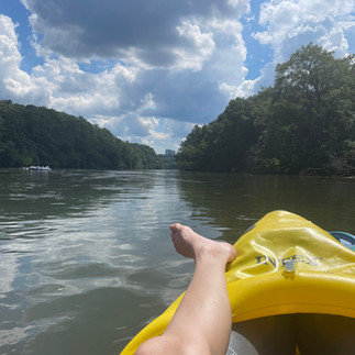


The specific stretch of the river preserves a 48-mile stretch of the Chattahoochee River stretching from Buford Dam down to Peachtree Creek in Atlanta. It is a federally protected National Recreation Area that features over 15 distinct parcels of land that offer hiking trails, fishing, and water recreation like tubing and kayaking.
Dry Tortugas National Park (Florida), 1992. (UNESCO World Heritage Site)


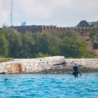
The islands of the Dry Tortugas, at the westernmost end of the Florida Keys, are the site of Fort Jefferson, a Civil War-era fort that is the largest masonry structure in the Americas. The park is home to undisturbed coral reefs and shipwrecks, and is only accessible by plane or boat.
Tuskegee Airmen National Historic Park (Alabama), 1998. (UNESCO World Heritage Site)


What an incredible visit this is. The Tuskegee Airmen National Historic Site is in Moton Field. It honors the over 15,000 Black men and women who participated in the U.S. Army Air Corps' experiment to train African American pilots and support staff during World War II.
Great Sand Dunes National Park (Colorado), 2004
Pictures coming soon
The tallest sand dunes in North America, up to 750 feet (230 m) tall, were formed by deposits of the ancient Rio Grande in the San Luis Valley. Abutting a variety of grasslands, shrublands, and wetlands, the park also features alpine lakes, six 13,000-foot mountains, and old-growth forests.
Gateway Arch National Park (Missouri), 2018


The Gateway Arch is a both high and wide 630-foot arch, to commemorate the Lewis and Clark Expedition, and the westward expansion of the United States. An underground museum contains the arch's construction and the country's westward expansion, a definite stop when in St. Louis.

Comments